
فائل:Americas independence map.PNG

هن پيش-نگاھ جي ماپ: ٤٠٧*٦٠٠ پڪزلس. ٻيا تحلل:١٦٣*٢٤٠ پڪزلس | ٣٢٦*٤٨٠ پڪزلس | ٨٦٢*١٬٢٧٠ پڪزلس
اصلوڪو فائيل (٨٦٢ × ١٬٢٧٠ عڪسلون، فائيل سائيز: ٧٤ KB، MIME ٽائيپ: image/png)

|
This historical map image could be re-created using vector graphics as an SVG file. This has several advantages; see Commons:Media for cleanup for more information. If an SVG form of this image is available, please upload it and afterwards replace this template with
{{vector version available|new image name}}.
It is recommended to name the SVG file “Americas independence map.svg”—then the template Vector version available (or Vva) does not need the new image name parameter. |
تَتُ
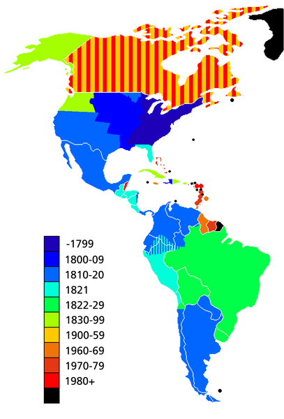
Map showing date of independence of country in the Americas. Black shows areas not yet independent.
Uses current boundaries, which may not correspond with the historical boundary of the country when it became independent. For example the United States was composed of 13 states on the East Coast when it became independent and did not reach its full continental extant until 1867 with the .
لائيسنسڪاري

|
ھن دستاويز کي جي.اين.يو مفت دستاويزسازي اجازتنامي ، مفت سافٽويئر فائونڊيشن پاران ڇاپيل ورزن 1.2 يا ٻي ڪنھن بعد واري ورزن؛ جنھن ۾ نہ انويريئينٽ ڀاڱا، ۽ نہ فونٽ-ڪور متنَ، ۽ نہ بيڪ-ڪور متنَ شامل آھن، جي شرطن ھيٺ نقل ڪرڻ، ورھائن ۽/يا بدلائڻ جي اجازت ڏني وئي آھي. اجازتنامي جو نقل [[c:Commons:GNU Free Documentation License, version 1.2 | جي.اين.يو مفت دستاويزسازي اجازتنامو]] نالي ڀاڱي ۾ ڏنل آھي. |
| ھي فائيل ڪريئيٽو ڪامنز انتساب-ھڪجھڙي ڀاڱيداري 3.0 انپورٽڊ اجازتنامي ھيٺ اجازتنامو ڏنل آھي. | ||
| ||
| This licensing tag was added to this file as part of the GFDL licensing update. |
فائيل جي سوانح
ڪنھن بہ تاريخ/وقت تي ٽڙڪ ڪري ڏسندا تہ ان وقت اهو فائيل ڪيئن هو.
| تاريخ/وقت | آڱوٺي ننھن | ماپَ | واپرائيندڙ | راءِ | |
|---|---|---|---|---|---|
| موجود نسخو | 14:23, 11 مَي 2019 | | ٨٦٢ × ١٬٢٧٠ (٧٤ KB) | Foghe | Removed Labrador border; only current international borders. |
| 03:32, 25 اپريل 2019 |  | ٨٦٢ × ١٬٢٧٠ (٤٤ KB) | Marcomogollon | I add disputed territory between Colombia, Ecuador and Peru | |
| 23:11, 3 آڪٽوبر 2011 |  | ٨٦٢ × ١٬٢٧٠ (٦٨ KB) | Lemonade100 | Added some current dependent territories and re-coded Canada - gained sovereignty in 1939 and full independence in 1982. | |
| 18:35, 9 نومبر 2010 |  | ٨٦٢ × ١٬٢٧٠ (٣٨ KB) | Minnecologies | Fixed error in northern Canada | |
| 17:25, 9 نومبر 2010 |  | ٨٦٢ × ١٬٢٧٠ (٣٨ KB) | Minnecologies | *Filled in Pacific Northwest *Added Saint Pierre and Miquelon *Updated the boundaries of Gran Colombia, Bolivia, and Peru *Changed color scheme to straight ROYGBIV | |
| 06:32, 20 آگسٽ 2007 |  | ٨٦٢ × ١٬٢٧٠ (٦١ KB) | AlexCovarrubias | Mexico independence year is 1810 | |
| 00:48, 7 ڊسمبر 2006 |  | ٨٦٢ × ١٬٢٧٠ (٤٩ KB) | Roke~commonswiki | include colonies | |
| 12:48, 22 مارچ 2006 |  | ٨٦٢ × ١٬٢٧٠ (٦٣ KB) | Roke~commonswiki | Map showing date of independence of country in the Americas Category: America |
فائيل جو استعمال
هن ”عڪس فائيل“ سان هيٺيان صفحا ڳنڍيل آهن: